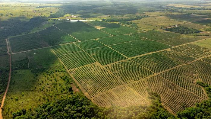
Four decades of satellite land-use data show the Pimentel Barbosa Indigenous Territory remained largely unchanged while the land around it was converted to pasture and cropland, a pattern researchers call “territorial islanding.”
Brazil’s Cerrado is the most biodiverse savanna on Earth, a vast mosaic of grasslands, shrublands and woodlands covering about a fifth of the country. It is also one of the world’s most important agricultural frontiers. Over the past half century, much of its native vegetation has been cleared for cattle pasture and soybean fields.
A new study shows how one Indigenous territory has held its ground amid that transformation. Researchers at the State University of Campinas (UNICAMP) and partner institutions analyzed nearly 40 years of land-use data for the Pimentel Barbosa Indigenous Territory, home to the Xavante, or A’uwẽ, people in northeastern Mato Grosso. They found that while the surrounding landscape was transformed, the territory itself remained largely intact.
The territory was officially recognized by a 1986 decree. “Since then, over the course of these 40 years, the landscape of the TIPB has remained virtually unchanged,” said Isabella Coelho de Oliveira, the study’s lead author, using the abbreviation for the territory’s Portuguese name. The results were published in Geocarto International.
Tracking four decades of change
The Pimentel Barbosa territory covers about 329,000 hectares, an area roughly twice the size of greater London, and had 2,369 residents in Brazil’s 2022 census. To understand how its landscape compared with its surroundings, the researchers studied land use inside the territory and within a 50-kilometer radius from 1985 to 2024.
They drew on MapBiomas, a collaborative Brazilian initiative that produces annual maps of land cover and land use across the country from satellite imagery. Using its Collection 10 data and multivariate statistical techniques, the team identified distinct phases in how the region changed.
In the first, which the researchers call the basal phase, from 1985 to 1995, the region was still dominated by native vegetation. A transitional phase, from 1996 to 2012, brought deforestation and the expansion of pasture. In the consolidation phase, from 2013 to 2024, the landscape outside the territory came to be dominated by soybean farming and large-scale livestock production.
“Initially, there was ecological continuity between the interior and exterior of the indigenous land,” said Anderson Targino Ferreira, a researcher at UNICAMP’s Institute of Geosciences and at CELAP/IPEN, a co-author. Over time, that continuity disappeared. “It was an intense process of eliminating local biodiversity, leaving behind precisely the territory defined by the TIPB,” he said.
An island in a sea of crops
The contrast is visible on the ground. “You only need to travel from south to north along BR-158 to notice that contrast,” Oliveira said, referring to a federal highway that runs through the region.
The researchers describe the pattern as territorial islanding, in which an Indigenous land becomes an isolated refuge of native ecosystems surrounded by converted land. Ferreira recalled that when Oliveira first raised the idea of territorial isolation with him, he told her the term did not exist in the literature.
Her supervisor, Vicente Eudes Lemos Alves, a professor at UNICAMP’s Institute of Geosciences, said the land-use data bear the idea out. “That contrast supports the concept of ‘territorial islanding,’” he said. “In this context, indigenous lands have become bastions of socio-environmental preservation.”
“What has remained is precisely what the indigenous lands have protected,” Alves added.
The finding echoes a broader body of research showing that Indigenous lands across Brazil and elsewhere in Latin America tend to have lower deforestation rates than surrounding areas, making them important for conserving biodiversity and storing carbon.
Roads, policy and drying landscapes
The authors link the regional transformation to 20th-century state policies that encouraged settlement and agricultural development in Brazil’s interior, and to major highways, including BR-158 and BR-163, which opened the region to farming and to markets.
The loss of Cerrado vegetation has consequences beyond the loss of species. The savanna’s deep-rooted plants help water soak into the soil and recharge aquifers that feed some of Brazil’s major rivers. The researchers note that clearing affects water infiltration and aquifer recharge, as well as the so-called flying rivers, airborne streams of moisture released by vegetation that carry rainfall across South America. Disrupting these processes can make the region more vulnerable to drought.
Mapping with the community
The research combined satellite analysis with fieldwork. Oliveira made four research stays in the territory, took part in community assemblies and ran workshops in which members of a Xavante guardian group learned to use a GPS-based mapping app.
“People learned how to use the app and export the waypoints – the first step in creating the map,” she said. “It was a very enriching exchange of knowledge.”
The fieldwork also highlighted that official boundaries capture only part of the picture. “For the A’uwe Xavante, the territory isn’t limited to the officially demarcated area,” Oliveira said. Places of cultural, spiritual and practical importance can lie outside the demarcated lands, meaning that changes in the surrounding landscape affect the community even when its territory is protected.
Beyond the map
The authors connect their work to several of the United Nations Sustainable Development Goals, including those on reduced inequalities, climate action, life on land and peace, justice and strong institutions. “And we also believe that this research can contribute to the recognition of SDG 18,” said co-author Maria Carolina Ribeiro, a researcher at CPTEn, referring to a proposed additional goal on ethnic and racial equality.
The study focuses on a single territory, and the researchers did not measure biodiversity directly on the ground. Land-cover maps derived from satellite data can also miss subtler forms of degradation, such as changes in fire regimes or the loss of particular species. Comparisons with other Indigenous lands in the Cerrado would help show how widespread the pattern of territorial islanding is.
Oliveira, who began the work as an undergraduate with FAPESP scholarships, received a Scientific Merit Award at UNICAMP’s 32nd Congress on Scientific Initiation in 2024. Her findings add to evidence that Indigenous territories are among the last strongholds of the Cerrado’s native landscapes, and that their protection is increasingly tied to the fate of the ecosystems around them.
Notes
- “Revealing indigenous territorial islanding in an agricultural frontier through land-use trajectories and multivariate analysis.” Geocarto International, 8 May 2026. DOI: 10.1080/10106049.2026.2670932.
- Fundação de Amparo à Pesquisa do Estado de São Paulo (FAPESP). “Indigenous territory maintains ecological stability amid agricultural expansion in the Brazilian savanna.” EurekAlert!, 31 July 2026. https://www.eurekalert.org/news-releases/1138447.
M. Silva


Leave a Reply