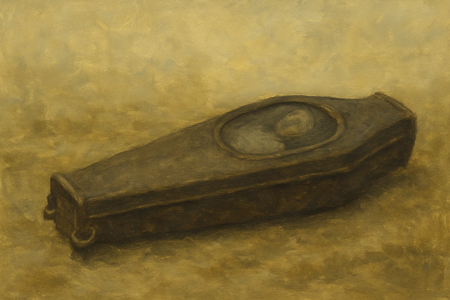
Across Part 1 and Part 2, forensic archaeologist Scott Warnasch walked us from a routine homicide call in Elmhurst to the revelation of Martha Peterson, the “Woman in the Iron Coffin.” He traced the science that safeguarded the scene, the clothing and biological profiles that narrowed the window of death, and the archival triangulation that connected Martha to Newtown’s free Black community—its church, its leaders, and its everyday resilience.
In this final installment, we follow the investigation to its hardest terrain: the politics of the site and the fragility of the historical record. Warnasch details why no formal archaeological report surfaced; how a developer–church stalemate froze work mid-excavation; and why documentation—already thin in 19th-century Newtown—grew even scarcer as Queens urbanized. He revisits the church’s origins under Rev. James W.C. Pennington, the school next door, and the outsized role of the Peterson family in anchoring a community that owned land, educated children, and planned burials with care even amid smallpox. We also situate Alfred P. Fisk—innovator of the iron coffin—within this landscape, placing Martha’s daily life at Maurice Avenue and Fisk Road. Finally, Warnasch weighs what may still lie beneath narrow fringes of the parcel—and what a digital reconstruction could return to public memory when the ground can no longer speak.

Marc Landas: Why do you think a report was never filed?
Scott Warnasch: We’ll have to get into a bit of site politics. I don’t know exactly when the property was purchased, but it was acquired before 2011—before Martha’s discovery—by a Chinese development consortium planning apartments (many of which are there now). They were keen to follow development protocols, and there was archaeological work done for permitting. In those preliminary backgrounds, it was clear the parcel had been a cemetery. If any ground-disturbing work was to happen, an archaeologist was supposed to be on site. They didn’t do that—they hired a backhoe operator. That opened a can of worms: they ended up desecrating what was, in effect, a cemetery for formerly enslaved and free Black people.
Also, Landmarks had said the property was purchased in 1828, but I have newspaper evidence that the burial ground was already in use by 1818.
Marc Landas: Where did you find the 1818 reference?
Scott Warnasch: In a column—I think it was called “Historical Notes”—from the Long-Island Star–type regional register (I’ll confirm the exact title). It summarized older events: Dutch Lane’s reconfiguration, the parcel’s odd triangular shape, and how a slice was cut to straighten the road. That portion was sold to William Hunter, who, about a year later, sold it to the African American Society of Long Island. The column also mentioned the 1818 use date.
Marc Landas: Did St. Mark’s AME keep any records?
Scott Warnasch: I haven’t obtained records from them. They were helpful to a degree, but they’re Methodist, whereas the original congregation was Presbyterian/Congregationalist. St. Mark’s didn’t come in until around 1900 or so.
Marc Landas: No burial records at all?
Scott Warnasch: Not necessarily. The church changed hands five times—starting with the Congregationalists under Rev. James W.C. Pennington, then Methodist, then back to Presbyterian, and St. Mark’s around 1906. The original church building was torn down and rebuilt in the early 1900s—Booker T. Washington even lectured there during fundraising for the windows.
I believe John Peterson (Martha’s father) served as sexton around 1870. The site remained in community memory, and interments continued into the turn of the century. There’s also the Corona Avenue widening, when twenty-something burials were removed—names were recorded. But St. Mark’s never gave me direct, in-ground data.
Originally, the developer offered to buy the church property and remove all graves to Mount Olivet, but locals opposed it and the permit was withheld—so it never happened. Eventually St. Mark’s left, leaving the burials in place and relocating the congregation. Older generations still knew who was buried there; I suspect there was discomfort with a different denomination deciding the fate of their ancestors. After the 1850s, Newtown’s Black population wasn’t a magnet for migration; numbers dropped, new people moved in, and the picture got less straightforward by the 1870s.
Marc Landas: Right. Let’s circle back to why no official archaeological report was produced.
Scott Warnasch: The developers were openly hostile toward St. Mark’s. They resented dealing with the burials. I was in the room for some of those conversations—they were dismissive and, frankly, racist about the dead. Their position was essentially, “How do we get these bodies out of here?” They refused to take responsibility and pushed everything onto St. Mark’s.
Marc Landas: When you say “gross,” you mean openly disrespectful?
Scott Warnasch: Yes. St. Mark’s, meanwhile, wanted proper recognition: landmark designation, a museum or visitor center—ambitious, and understandable. The developers said, “We’re not paying for any of that.” Stalemate. That froze further development beyond what was already on the books; some construction did proceed after 2011, but the broader project stopped. The Chinese consortium ultimately pulled out—during the excavations of another iron coffin and additional skeletons. They never paid the archaeologists. That’s why no formal report was generated.
Marc Landas: So the legal responsibility sat with the property owner?
Scott Warnasch: Exactly. By law, the owner is the steward of what’s found—artifacts or human remains. We often encourage donation of artifacts to museums, but the bills and decisions are the owner’s. St. Mark’s no longer owned the site. They wanted information and preservation outcomes, but they weren’t legally on the hook.

Marc Landas: Let’s talk about the church’s importance. Pennington was probably the first pastor, right?
Scott Warnasch: Yes. The church became the community’s heart—like most small-town churches. Pennington founded it in 1837 (ordained in 1838). I have the clipping. It wasn’t tied to a strict denomination at first—more a refuge for Black residents who didn’t want to sit in segregated pews elsewhere. It functioned as a community center.
Pennington also served as the first teacher at the African American school next door: Sabbath schools, night classes, women’s classes. He only lived in Newtown intermittently over ~30 years—he left to be ordained in Connecticut—and Samuel Ringgold Ward followed as teacher and prominent abolitionist. The church was the gathering place for community and civic life.
Marc Landas: What does the Peterson family’s presence tell us about community size and stability?
Scott Warnasch: The Petersons were a force. By 1850, they were the largest extended Black family in Newtown. Several owned property. I found one clue that John Peterson was born in Philadelphia around 1800—by then slavery there was essentially gone, with thousands of free Blacks. That suggests the Petersons were free early and had a head start—opportunities to earn, buy land, and put down roots.
John was central—he helped create the platform that allowed Pennington to flourish. They were close: he named his youngest son John Pennington Peterson. Other leaders—the Coles, Potter, and Derling families of the United African Society—also represented a higher stratum. John Potter died young and was definitely emancipated; Derling was likely enslaved under Remsen; John Peterson probably was not.
Marc Landas: Most censuses list John Peterson’s birthplace as New York. What’s your evidence for Philadelphia?
Scott Warnasch: John Pennington Peterson’s death certificate lists his father’s birthplace as Philadelphia. Censuses weren’t perfect—often one person answered the door and guessed ages or places of birth. If John arrived as an infant, neighbors would assume he’d been born locally.
Marc Landas: Where did John Peterson live?
Scott Warnasch: On Justice Avenue.
Marc Landas: How do you know?
Scott Warnasch: I “triangulated” the 1830 and 1840 censuses against named-owner maps (like Riker’s), aligning known white landholders with nearby Black households. In the 1830s, John lived near Dutch Lane, close to the Dutch Lane church/school parcel. By 1840, he’d moved to Justice Avenue. In the 1830 census there are five Peterson patriarchs—three in Trains Meadow long-term; John is the one who shifts toward Justice Avenue.
Marc Landas: And he stayed on Justice Avenue the rest of his life?
Scott Warnasch: As far as I can tell. Censuses and city directories list him there into the late 1860s or early 1870s. He’s listed as a laborer.
Marc Landas: Were the Petersons typical of Newtown’s free Black families?
Scott Warnasch: Hard to say. They’d been there a long time, so they represent the “indigenous” free Black population, but their status may have been higher than many others. The United African Society officers clearly had some means—buying the church parcel in 1828 placed them above much of the community economically. Others (like Jacob and another John Peterson) owned property too, but I don’t always have the purchase dates.
Marc Landas: Have you located any descendants?
Scott Warnasch: No. I have Martha’s DNA sample. I asked St. Mark’s to check surnames among congregants—none matched historic families; most congregants migrated later from Jamaica or the U.S. South. I’ve paused deeper DNA work to finish the book—there’s a lot already. I’ll keep working after it’s out, but contacting families can become its own complicated project.
Marc Landas: Based on your findings, how did Black Newtowners handle death and burial—before and after the mid-19th century?
Scott Warnasch: Martha’s clothing is one of the clearest snapshots of African American funerary practice circa 1851. Many rituals mirror white Presbyterian/Congregationalist customs—beliefs and material culture were shaped by the same rural environment. John and Jane Peterson attended a white Presbyterian church before Pennington established Dutch Lane, so practices naturally overlapped.
I’ve only seen distant photos of the churchyard—hard to compare stone counts to probable burials. But Martha’s careful grooming, hair, manicured nails—despite smallpox—shows a deep commitment to proper presentation. Smallpox funerals, while dangerous, were sadly familiar; communities had strategies and some immunity.

Marc Landas: Do you have a rough sense of where the school stood?
Scott Warnasch: Right next door—essentially where 90th Street/Pennington Road is now—directly beside the churchyard.
Marc Landas: Why doesn’t it appear in surviving photos?
Scott Warnasch: Possibly it didn’t last long. Pennington’s autobiography precisely describes the location.
Marc Landas: Thinking forward: in a perfect world, what could be done on the current site—future digs, technologies—to recover more about the place and people?
Scott Warnasch: It’s tough to say—I was never part of a comprehensive site survey. I was there for a body and a few disturbed burials. Other archaeologists could better estimate intact areas. Looking at building footprints—a screen factory, other structures—it’s amazing Martha’s coffin survived in an alley-width strip near edges and lot lines.
There could still be burials tucked along those margins, but much is likely gone. Ultimately, the African American community should decide outcomes. St. Mark’s has a vision; I’m fine with that. It’s significant and deserves formal recognition, but it’s awkward for public visitation. A virtual reconstruction—streetscape, church, school—would be powerful. And the missing archaeology reports should be generated so the information isn’t lost.
Marc Landas: Any newer technologies worth deploying, or is the site too disturbed?
Scott Warnasch: Better instruments help, but honestly, the right excavator + archaeologist is what yields results; information comes from careful recovery and analysis. Tech isn’t a silver bullet here. For interpretation, though, a digital reconstruction of, say, 1839—school and church in place—would be great.
Marc Landas: Anything under the street—like 90th Street?
Scott Warnasch: I don’t think so. The original parcel boundaries didn’t really change; the railroad came later. Superimpose all later buildings and you’re left with only small peripheral pockets. Those could still hold burials, but it’s limited.
Marc Landas: Queens—especially Newtown—was agricultural. No massive masonry like Manhattan. Now it’s paved and built over. Is the past essentially lost?
Scott Warnasch: It was largely lost at the time. There are very few records. Even historian Siegfried wrote that Newtown is a blank spot—Black and white—between the Revolution and the 1850s. Town minutes exist but don’t convey lived experience. If development destroyed the archaeology and there were no newspapers or diaries, there aren’t many avenues left.
There are stories, though. Alfred P. Fisk is a major one—an early figure in the developing funeral industry based in Queens. He literally made presidential coffins in his backyard. And Martha’s house was at Maurice Avenue and Fisk Road (69th Street)—not where most maps place the foundry (up near Shell Road/Queens Boulevard). Fisk had two houses on the far end of his property; that’s where Martha lived, near the original foundry that later burned.
Marc Landas: Did she live with other domestics—and was the house attached to Fisk or to Raymond?
Scott Warnasch: Fisk bought the property in 1845 from another foundry owner. It was ~80 acres with a small existing foundry—part of why he chose it. The Petersons likely had ties to that farm already: Henry as head farmhand, Martha as domestic. Earlier owners had enslaved workers there, so Black presence on that parcel goes back.
Fisk moved into an older house (supposedly Revolutionary-era), cut Fisk Avenue (now 69th Street) in 1847, then—after securing his patent—built a second house and moved his family. William Raymond, his sister Josephine, Martha, and Henry occupied the older house. Raymond arrived ~1849. I suspect Henry and Martha were already there and came with the property—you don’t buy an 80-acre farm without people who know how to run it.
Their cousin/uncle Jacob Peterson appears on the Fisk deed as a boundary neighbor, underscoring the long-standing relationship between Fisk and the African American community along Shell Road. It all triangulates: the Petersons were there even before Fisk.
Marc Landas: That triangulation is compelling.
Scott Warnasch: It is—and it ties Martha’s life to the physical and social landscape that produced the “Woman in the Iron Coffin.”


Leave a Reply