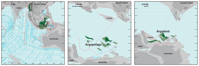
Geologists have long known that around 155 million years ago, a 5000 km long piece of continent broke off western Australia and drifted away. They can see that by the ‘void’ it left behind: a basin hidden deep below the ocean known as the Argo Abyssal Plain. The underwater feature also lends its name to the newly formed continent: Argoland. The structure of the seafloor shows that this continent must have drifted off to the northwest, and must have ended up where the islands of Southeast Asia are located today. But surprisingly, there is no large continent hidden beneath those islands, only the remnants of small continental fragments that are also surrounded by much older oceanic basins. So what happened to Argoland? Geologists at Utrecht University have now managed to reconstruct the history of the lost continent. As it turns out, Argoland is in fragments, but is still there. “Otherwise, we would have been faced with a major scientific problem.”
Geologists differentiate the earth’s crust into the heavier oceanic crust and lighter continental crust. These lighter continents may be partially hidden below sea level, as was also the case with another ‘lost’ continent, Greater Adria. Like Argoland, it also consisted of different fragments separated by narrow ocean basins, which eventually became part of a single tectonic plate. At some point in the past, Greater Adria plunged into the earth’s mantle, but the top layer stayed behind and was folded to form the mountains of Southern Europe. Argoland, however, left no such trace in the form of folded rock strata.

“If continents can dive into the mantle and disappear entirely, without leaving a geological trace at the earth’s surface, then we wouldn’t have much of an idea of what the earth could have looked in the geological past. It would be almost impossible to create reliable reconstructions of former supercontinents and the earth’s geography in foregone eras”, explains Utrecht University geologist Douwe van Hinsbergen. “Those reconstructions are vital for our understanding of processes like the evolution of biodiversity and climate, or for finding raw materials. And at a more fundamental level: for understanding how mountains are formed or for working out the driving forces behind plate tectonics; two phenomena that are closely related.”
Van Hinsbergen and his colleague Eldert Advokaat were curious about what the geology of Southeast Asia could tell about Argoland’s fate. “But we were literally dealing with islands of information, which is why our research took so long. We spent seven years putting the puzzle together”, says Advokaat. “The situation in Southeast Asia is very different from places like Africa and South America, where a continent broke neatly into two pieces. Argoland splintered into many different shards. That obstructed our view of the continent’s journey.” But that was until he realised that the fragments arrived at their current locations at around the same time, which clarified how they once connected together. The shards formed a collage: Argoland is hidden beneath the green jungles of large parts of Indonesia and Myanmar.
Sign up for the Daily Dose Newsletter and get every morning’s best science news from around the web delivered straight to your inbox? It’s easy like Sunday morning.
That splintering is typical for the microcontinent. There was never a single clearly delineated and coherent continent of Argoland, but rather an ‘Argopelago’ of microcontinental fragments separated by older oceanic basins. In that it resembles Greater Adria, which by now has almost entirely subducted into Earth’s mantle, or Zeelandia, the largely submerged continent east of Australia. “The splintering of Argoland started around 300 million years ago”, Van Hinsbergen adds.
The puzzle that Advokaat and Van Hinsbergen have solved fits seamlessly between the neighbouring geological systems of the Himalayas and the Philippines. Their detective work also explains why Argoland is so fragmented: the break-up accelerated around 215 million years ago, as the continent shattered into thin splinters. The geologists conducted field work on several islands, including Sumatra, the Andaman Islands, Borneo, Sulawesi and Timor, to test their models and determine the age of key rock strata.
IMAGE CREDIT: Utrecht University.
If you enjoy the content we create and would like to support us, please consider becoming a patron on Patreon! By joining our community, you’ll gain access to exclusive perks such as early access to our latest content, behind-the-scenes updates, and the ability to submit questions and suggest topics for us to cover. Your support will enable us to continue creating high-quality content and reach a wider audience.
Join us on Patreon today and let’s work together to create more amazing content! https://www.patreon.com/ScientificInquirer


Leave a Reply