HAVE YOUR SAY.
Join us in The Bullpen, where the members of the Scientific Inquirer community get to shape the site’s editorial decision making. We’ll be discussing people and companies to profile on the site. On Wednesday, March 8 at 5:30pm EST, join us on Discord and let’s build the best Scientific Inquirer possible.
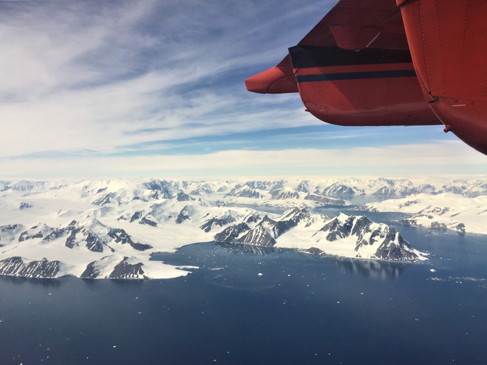
Glaciers – giant blocks of moving ice – along Antarctica’s coastline are flowing faster in the summer because of a combination of melting snow and warmer ocean waters, say researchers.
On average, the glaciers travel at around one kilometre a year. But a new study has found a seasonal variation to the speed of the ice flow, which speeded up by up to 22 % in summer when temperatures are warmer. This gives an insight into the way climate change could affect the behaviour of glaciers and the role they could play in raising sea levels.
Up to now, study of the rugged Antarctic peninsula has been limited because of the difficulties scientists face getting on to the glaciers to conduct fieldwork. But from space, advances in satellite technology are revealing new insights into the speed at which the glaciers are moving and draining water into the surrounding ocean.

Antarctic peninsula – and global sea levels
The Antarctic Peninsula is the largest reservoir of frozen water on Earth. It is estimated that between 1992 and 2017, melt water from the glaciers increased global sea levels by around 7.6 mm. How that may change in the future is one of the big uncertainties in modelling climate change.
A team of researchers, led by scientists at the University of Leeds, has used more than 10,000 satellite images, taken above the Antarctic Peninsula between 2014 and 2021, to understand how the flow of glaciers into the waters around the Antarctic alters during colder and warmer periods.
Ben Wallis, a doctoral researcher and first author of the study, said: “One of the important findings of this study is that it reveals how sensitive glaciers in Antarctica are to the environment. We have known for a long time that glaciers in Greenland have a seasonal behaviour, but it is only now that satellite data has shown similar behaviour in Antarctica.”
The paper is published today (27/2) in the journal Nature Geosciences. When the embargo lifts, the paper will be available from the Nature website https://www.nature.com/articles/s41561-023-01131-4
Antarctic Peninsula
The Antarctic Peninsula is the most northern and warmest region of Antarctica. It has a 1,000 km long mountainous spine, similar to the length of the east coast of Great Britain, and home to a rich marine ecosystem of seals, penguins and whales.
Along the west coast of the peninsula, the glaciers drain ice from the ice sheet directly into the Southern Ocean.
Analysis of the satellite data showed that the glacier speed-up occurs in summer as snow melts and the temperature of the waters in the Southern Ocean rise. It is thought that water from the melting snow acts as a lubricant between the ice sheet and the underlying rock. As a result, friction is reduced and the speed at which the glaciers slide increases.
In addition, the warmer waters of the Southern Ocean erode the front of the moving ice, which reduces the buttressing forces it exerts to resist the ice flow.
Dr Anna Hogg, Associate Professor in the Institute for Climate and Atmospheric Science at Leeds and an author of the paper, said: “The Antarctic Peninsula has seen some of the most rapid warming of any region on Earth. Continuing work like this will help glaciologists monitor how quickly change is occurring, enabling accurate assessments of how Earth’s ice will respond to climate change.”
Earth observation from space
The European Space Agency and European Commission Copernicus Sentinel-1 satellite, whose data was used in this study, provides weekly monitoring around the whole coastline of Antarctica.
The satellite is fitted with synthetic aperture radar which can “see” through clouds, enabling measurements of the glaciers to be taken both day and night.
Craig Donlon of the European Space Agency said: “This study highlights how high-resolution satellite images can help us monitor how the environment is changing in remote regions. Future satellites, such as the family of Copernicus Sentinel expansion missions, promise to bring enhanced continuity and capabilities that will spearhead further insight into the characteristics and processes governing ice mass balance and sea-level rise.”
IMAGE CREDIT: Dr Anna E. Hogg, University of Leeds


Leave a Reply